

(Source: MIT)
Using satellites to capture the colorful images of space is no longer an issue. Now the company called DigitalGlobe wants to make this business bigger and stronger - to use artificial intelligence technology to further monitor the grass on Earth. .
According to foreign media reports, DigitalGlobe is working with the United States intelligence agencies (CIA), Amazon, Nvidia and other companies to create a project called CosmiQ, designed to train AI technology to glimpse what is happening on our planet every day.
DigitalGlobe recently unveiled a satellite image that reduced Rio Grande into a 50-cm resolution photo. The 200,000 buildings in the city's roughly 1900 square kilometers have been manually tagged in photos using artificial intelligence.
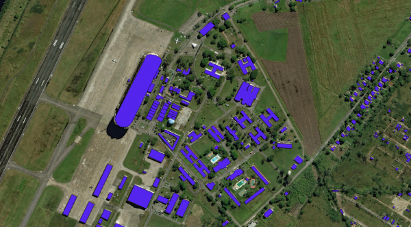
AI helps to outline the building in the marked area
The R&D staff hopes that 60 million space photos can be collected through satellites and a SpaceNet database will be set up. Photos will then be displayed to the public. And this SpaceNet data set is to be able to continue to train more skilled machine learning algorithms, so that itself can provide a higher-resolution satellite photos.
DigitalGlobe said that the SpaceNet dataset should eventually include a high-resolution image of 500,000 square kilometers of Earth, and it will add annotations to everything on the earth, not just buildings. DigitalGlobe claims that they are able to provide pictures with higher resolution than companies that have publicly provided satellite imagery, such as NASA's aerial image.
At the same time, Amazon will use its outstanding cloud computing services to provide data to SpaceNet. Nvidia will also provide data tools to help machine learning researchers train and test algorithms, and the CIA's venture capital department is also supporting the project.
"For this data set, we need to develop new algorithms," said Tony Frazier, senior vice president of DigitalGlobe. The company is also operating four imaging satellites and providing data to U.S. intelligence agencies and some humanitarian agencies to help humans extract valuable data from images.
Frazier said that they will train AI to mark the location and structural information of all buildings, such as the building's floor area and height, roof materials, solar panels, and swimming pools. Such information will achieve a high degree of accuracy and provide valuable reference for many industry applications such as insurance risk modeling, urban planning, emergency planning and management, business intelligence, scientific research and policy development.
Currently, DigitalGlobe has developed a geographic information big data platform and has created a collaborative ecosystem based on it. However, in order to be able to analyze the entire planet on a large scale and provide the necessary technical support for important decisions, they still have a long way to go.
Recommended reading:
When the world shifts priority from mobile to AI, future business competition will win in the "dimension"
“You are sick!†Between words, AI can diagnose mental disorders.
Did you send a message to nobody? AI gives you support